
202221 Tanker hits charted shoal while approaching berth.
As edited from MAIB (UK) report 15/2021
A chemical carrier was inbound for a port in good visibility and weather conditions. This was the first time the Master and OOW had entered this particular port.
In preparing the passage plan, slack water had been chosen as a time best suited to berth as the tidal stream would be minimal. Low water was predicted to be at 1515 with a height of 1.1 metres, and the plan was to arrive around this time. The next daylight slack water was just over 19 hours later at high tide with a height of 4.7 metres.
In the final approach, the OOW advised the Master of a 4.9 metre charted depth just north of the pier. Since the state of the tide was low at 1.1 metre and the vessel was drawing 6.2 metres aft, this meant they would touch bottom if they passed over this charted depth. The Master responded that the echo sounder was reading 7.0 metres of water so he was content to proceed with the berthing. As the vessel approached, now 50 metres north of the pier, there was a sudden shudder throughout the ship. The bow swung to the south and the vessel came to a stop. After several attempts to clear the vessel the Master succeeded and, with the now rising tide, they berthed under their own power.
It was found that No.5 main ballast tank was experiencing an ingress of water, so the ballast pumps were started to control the flooding.
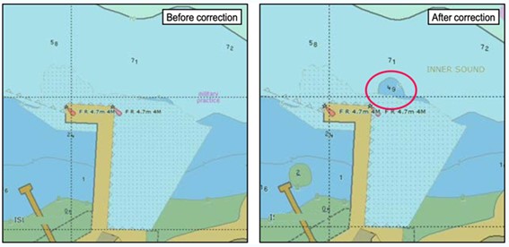
The investigation found that the 4.9m charted depth, 50m north of the pier, was brought to the attention of the Master while preparing the passage plan. Such a shoal would prevent the vessel from safely berthing at low water. The ECDIS ENC data was compared with the local survey chart and a photocopy extract of the Admiralty chart provided by the agent, neither of which showed the 4.9m feature. Reasoning that latter data was more recent, the Master directed the passage plan to be completed ignoring the 4.9m charted depth on the ENC.
As it transpired, neither the Master nor the officer had checked the update status of the ENC as part of the planning process. Both were unaware that the 4.9m obstruction was a recent correction dated only eight days before the grounding. It was, in the end, more recent and accurate than the agent’s pre-arrival information.
Lessons learned
- The safest passage plan is one which relies on the most accurate and recent navigation data. Make sure to check yours.
- Entering a new port (for the bridge team) with known strong tidal currents, without pilotage and with critical under keel clearance is a scenario that calls for extra care. Even discounting the fact that the Master believed the 4.9m depth was outdated, entering at high tide slack water would be a better choice than low tide slack water.
Source – The Nautical Institute